|
So we have just made available a draft of our new report Opportunities for open data sharing for effective land reform planning, implementation and producer support: Examining the information ecosystem in Matzikama which you can download from the link above. This report sets out to locate the Matzikama area-based planning project in context. It has drawn on a combination of key informant interviews, a small survey and desktop research to compile a preliminary map of the information ecosystem listing some of the data sets available as well as providing insights into the typed of data needed for area-based planning for land reform and provision of effective producer support. It has identified functional data literacies required across the board as well as key elements in a multidimensional data skills framework. Overall, we are still left with key questions as to how to best align existing systems and identify operational and management champions at different levels. What data is needed for local area based land reform planning at local municipality scale? So, if we are to plan effectively for land reform and the provision of producer support what data will we need and how can this data be obtained, shared and used by different actors? 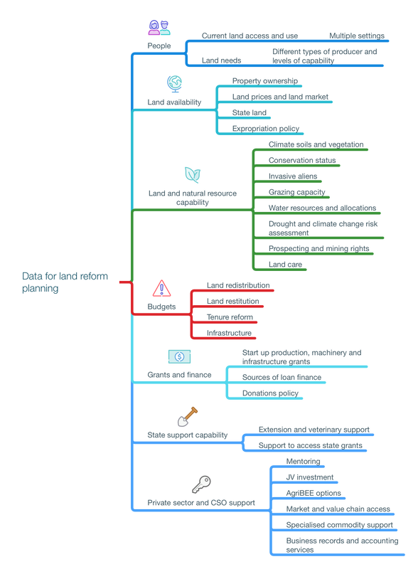 The mind map above provides an overview of some of the data requirements. It also highlights a critical constraint with current budget allocations which severely limit the scope of state funded and supported land reform. This is discussed further below, together with the shrinking pool of grants and finance options for land reform. Starting with people Our starting point is that land reform planning should be grounded in information about people and their needs across a variety of different settings. Currently reliable and up to date data on people in these different categories is hard to find. Available information is highly fragmented being held in spreadsheets, reports and databases by different data custodians. Data formats vary widely creating challenges for interoperability. Much data is not current as it is expensive to update. Data has to be cleaned and reformatted consistent with shared metadata standards before it can become accessible and useable. Next steps We are approaching that the Western Cape Spatial Information Forum (WCSIF) to present this report. The WCSIF will be the best forum to take this further in partnership with the Matzikama Local Municipality. The WCSIF was established in 2012 and meets biannually. It brings together key state and nonstate actors. Its constituting document states that the primary objectives of the WCSIF are to:
0 Comments
Leave a Reply. |
Phuhlisani NPCPlanning Pilot facilitator Archives
June 2022
Categories |
 RSS Feed
